Log inSign up
Log inSign up
Disasters Charter
4,321 posts
Disasters Charter profile banner
@DisastersChart

Disasters Charter

@DisastersChart
Satellite data to support disaster response worldwide
disasterscharter.org/home
Joined October 2009
284 Following
11.5K Followers
RepliesRepliesRepostsRepostsMediaMedia

Log in or sign up for X

See what’s happening and join the conversation

Continue with phone
or
Log in with username or email
Terms·Privacy·Cookies·Accessibility·US TIDA·Ads Info·© 2026 X Corp.
  • @DisastersChart
    Disasters Charter
    @DisastersChart
    Oct 8
    The International Charter was honoured to received the @iafastro 2026 World Space Award on Monday. The award recognised the Charter's more than 25 year history of international cooperation in using space-based assets to support disaster response worldwide: disasterscharter.org/news/internati…
    Photo of the IAF 2026 Space Award ceremony, held at the International Astronautical Congress on 5 October. Credit: International Astronautical Federation (IAF)
    International Astronautical Federation (IAF) and 9 others
  • @DisastersChart
    Disasters Charter
    @DisastersChart
    Sep 29
    In our latest article, @uaespaceagency describe their partnership with @space42ai. Learn about how Space42 are supporting the Charter and using AI to help analyse Earth observation data for disaster monitoring: bit.ly/4iPLk5L
    Comparison of Akmola in Kazakhstan before and after fires in June. False-colour Landsat 9 data were used to identify burn scars.
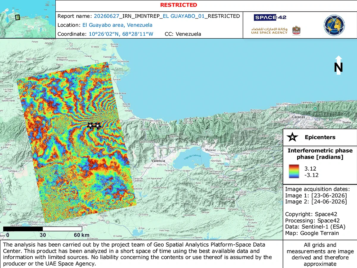
    Interferogramme of the El Guayabo area in Venezuela after the earthquake in June. The map uses data from Sentinel-1, processed in Space42's geospatial platform to estimate ground deformation following the earthquake.
    وكالة الإمارات للفضاء and Space42
    1
  • @DisastersChart
    Disasters Charter
    @DisastersChart
    Sep 1
    The Charter has been activated to provide satellite data over the flood in Nepal: bit.ly/4iFdcJA We have a series of maps available, estimating the impact of the disaster at different locations.
    Map of the mudflow and rockflow in Rasuwa District, Nepal. The map uses Sentinel-2 imagery from 27 August to estimate the extent of the mud and rocks in flooded areas.
    Comparison of the Trishuli Hydro Power Dam before and after the flood in Nepal. The comparison uses imagery from WorldView and NewSat before and after the disaster.
    Flood map of the area between Timure and Syaburbensi in Nepal. The map uses Pleiades Neo imagery from 28 August to estimate the impact of the flood.
    Comparison of Gerkhutar in Nepal before and after the flood. The comparison uses multispectral imagery from ResourceSat-2 and PeruSat-1 to compare the area before and after the disaster.
    ISRO and 9 others
    4
  • @DisastersChart
    Disasters Charter
    @DisastersChart
    Aug 12
    The Charter has been activated to provide satellite data over Monday's 7.4 magnitude earthquake in Colombia: bit.ly/4gcpLt9
  • @DisastersChart
    Disasters Charter
    @DisastersChart
    Aug 6
    The Charter has been activated to provide satellite data over the flood and mudslides in Sri Lanka: bit.ly/4pWPw4W